library(sf)          # dealing with spatial tables
library(terra)       # handeling raster data
library(tidyterra)   # handeling terra
library(tidyverse)
library(ggspatial)   # some useful ggplot2 additions
library(ggrepel)     # handeling text on plots
library(patchwork)   # for assembling multiple ggplots
library(maps)        # some basic country maps
library(mapdata)     # higher resolution maps
library(marmap)      # access global topgraphy data
library(mregions) # access to various marine regions, including EEZMaps in R
Reference map
Maps as background for ggplot-plot can come from myriad of sources. Here we take an example of shoreline that reside in the {map} and {mapdata}-packages as well as from GADM. The latter provides generally a higher resolutions of countries shoreline than the two former data-sources.
{mapdata}
To get the data into required ggplot2 form (a dataframe) we use the map_data-function:
my_region <- "Saint Lucia"
lca <- map_data("worldHires", region = my_region)
lca |> glimpse()
Rows: 188
Columns: 6
$ long <dbl> -60.93836, -60.94335, -60.94695, -60.95137, -60.95475, -60.9…
$ lat <dbl> 13.71776, 13.71581, 13.71277, 13.71002, 13.70945, 13.71500, …
$ group <dbl> 1, 1, 1, 1, 1, 1, 1, 1, 1, 1, 1, 1, 1, 1, 1, 1, 1, 1, 1, 1, …
$ order <int> 1, 2, 3, 4, 5, 6, 7, 8, 9, 10, 11, 12, 13, 14, 15, 16, 17, 1…
$ region <chr> "Saint Lucia", "Saint Lucia", "Saint Lucia", "Saint Lucia", …
$ subregion <chr> NA, NA, NA, NA, NA, NA, NA, NA, NA, NA, NA, NA, NA, NA, NA, …Here we have just a simple dataframe with 188 coordinates (long and lat) and some other variables. We can try map these coordinates to different layers:
m <-
  ggplot(lca, aes(long, lat, group = group)) +
  labs(x = NULL, y = NULL)
m1 <- m + geom_point(size = 0.5) + labs(title = "geom_point")
m2 <- m + geom_line() + labs(title = "geom_line")
m3 <- m + geom_path() + labs(title = "geom_path")
m4 <- m + geom_polygon() + labs(title = "geom_polygon")
m1 + m2 + m3 + m4  # patchwork package handles this nicely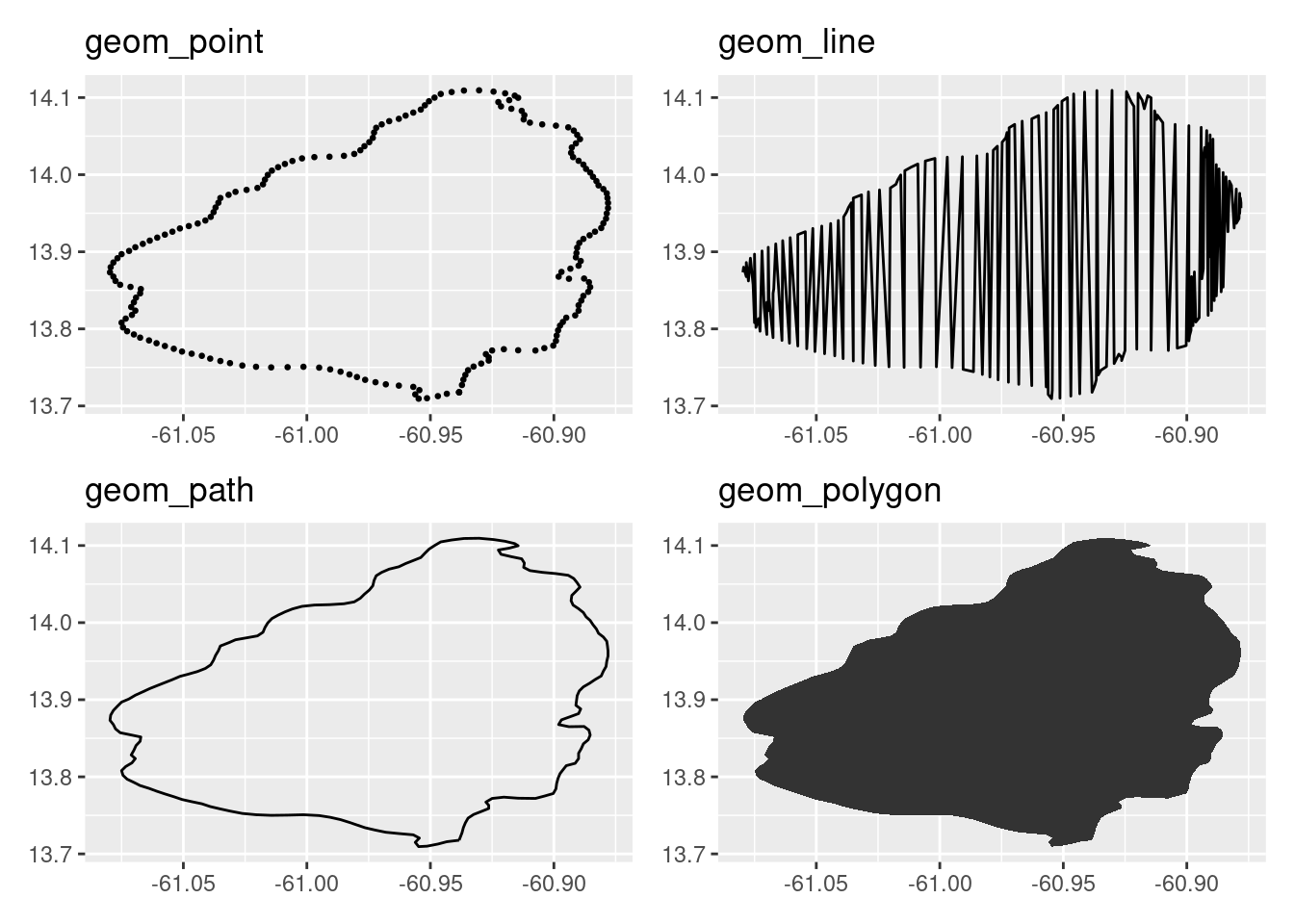
There is nothing magic about background “map” data. In principle it is just ordered x- and y-points, of which geom_path and geom_polygon handle nicely. The group argument above is useful e.g. if a country has more than one entity (like islands). An example is Guadeloupe:
glp <-
  map_data("worldHires", region = "Guadeloupe") |>
  ggplot(aes(long, lat, group = group)) +
  geom_path()
glp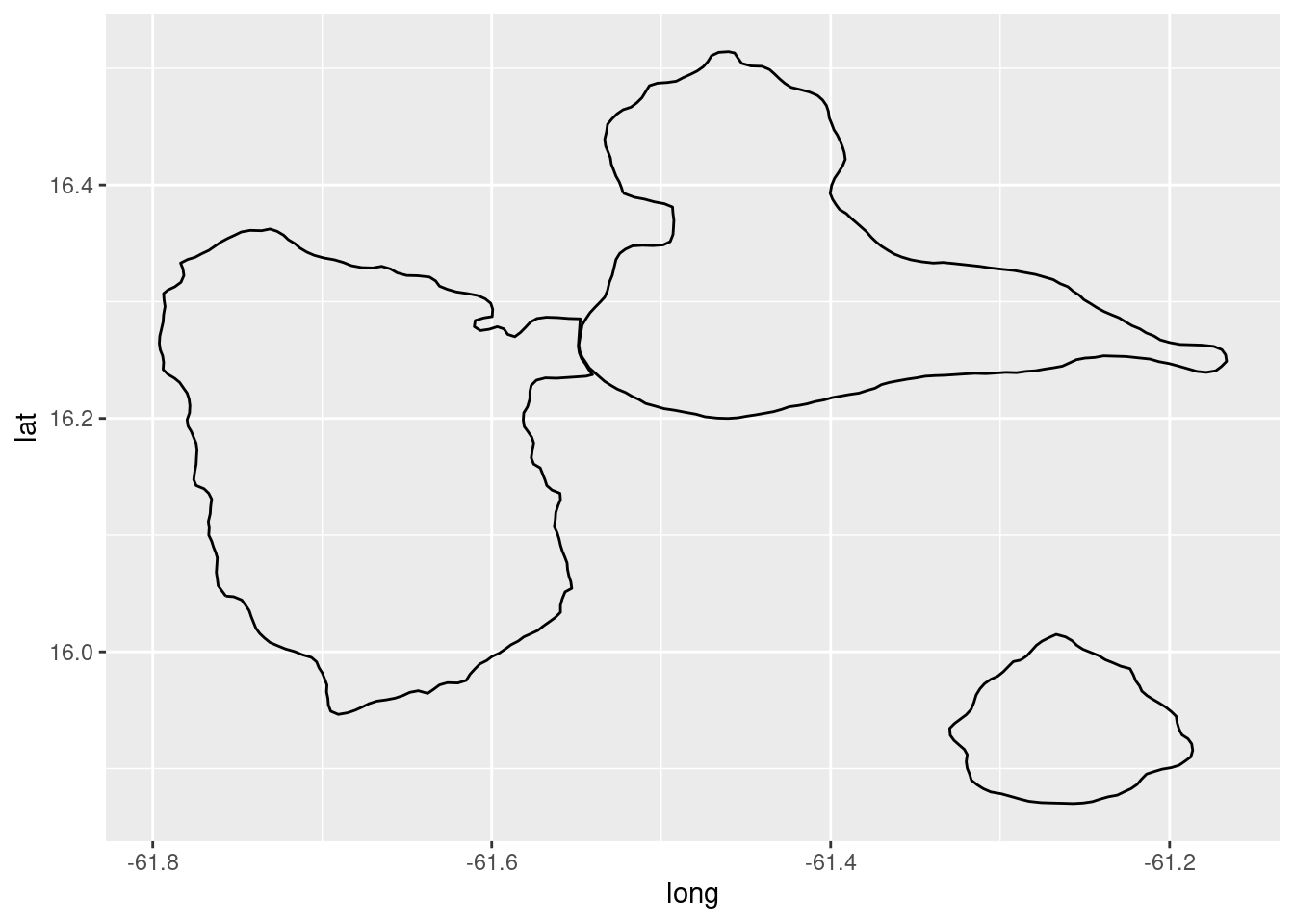
There one additional thing that is needed when plotting maps and that is the aspect ration, i.e. the ratio of the dimensions between x (longitude) and y (latitude). For ordinary dataframes, {ggplot2} provides two functions for that: coord_quickmap and coord_map, nomally the former is sufficient:
glp + coord_quickmap()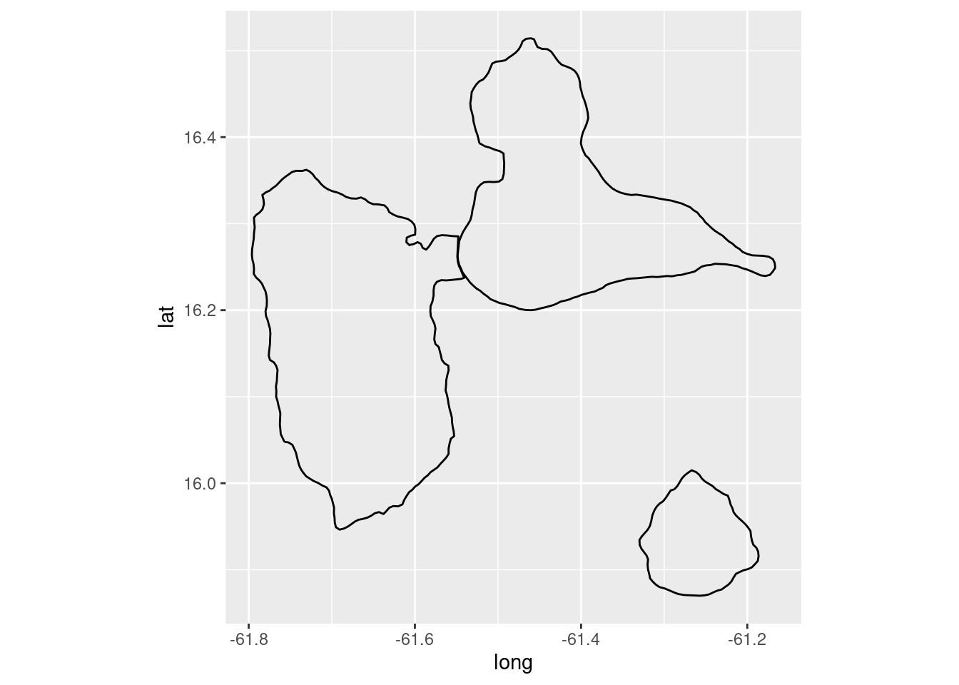
Those that are familiar with both St. Lucia and Guadeloupe know that the outlines of the countries as plotted above are very course. And in the case of Guadeloupe some of the smaller islands are actually missing. In general the map resolution needed depends on the purpose of the plot and scale of the plot. The resolution of the shoreline above would suffice if we were to plot a map on a regional scale. However the details may not be sufficient if one were to create a map on a country scale.
GADM
A little better resolution than provide by the {map}- and {mapdata}-package is that provided by GADM - a list of the available countries can be obtained here. To a map of a country one needs to specify the 3-letter country code. We can read a map of Guadelupe directly into R:
# Generate a handy function, in case we want any country map
read_gadm <- function(country_code = "LCA") {
  pth <- paste0("https://geodata.ucdavis.edu/gadm/gadm4.1/gpkg/gadm41_",
                country_code,
                ".gpkg")
  suppressWarnings(read_sf(pth))
}

glp <- read_gadm(country_code = "GLP")
class(glp)
[1] "sf" "tbl_df" "tbl" "data.frame"The class of the object (“sf”) returned may be novice for the beginner. Let’s take a peek:
glpSimple feature collection with 1 feature and 2 fields
Geometry type: MULTIPOLYGON
Dimension: XY
Bounding box: xmin: -61.81014 ymin: 15.83153 xmax: -61.00014 ymax: 16.51486
Geodetic CRS: WGS 84
# A tibble: 1 × 3
GID_0 COUNTRY geom
<chr> <chr> <MULTIPOLYGON [°]>
1 GLP Guadeloupe (((-61.60986 15.83875, -61.60986 15.83847, -61.60958 15.8384…We actually have a dataframe with a variable named “geom” that is of class MULTIPOLYGON. In the header we get then some additional spatial information. What we have is simply dataframe with some very special spatial constructs within it. If you want to delve into the spatial realm of the R we suggest the following two books:
Take note that the in the above dataframe we do not have any variables that correspond to longitute and latitude, since they are actually stored within the geom(etry)-variable. To plot such spatial objects we simply call the geom_sf-function:
ggplot() +
  geom_sf(data = glp)
Note that here we do not need to call coord_quickmap because the projection is taken care of when we call geom_sf.
We can easily add layers to a map, like landings locations and names in St. Lucia:
# get a gadm-map of St. Lucia
lca <- read_gadm(country_code = "LCA")
# landings sites
sites <-
  tribble(~site          ,        ~lon,     ~lat,   ~type   ,
          "Anse-La-Raye"   , -61.04358, 13.94095, "Primary"   ,
          "Bannanes"       , -61.00056, 14.01117, "Secondary" ,
          "Canaries"       , -61.06785, 13.90629, "Secondary" ,
          "Castries"       , -60.99230, 14.01618, "Primary"   ,
          "Choiseul"       , -61.05047, 13.77464, "Primary"   ,
          "Dennery"        , -60.88690, 13.91171, "Primary"   ,
          "Gros-Islet"     , -60.95271, 14.07893, "Primary"   ,
          "Laborie"        , -60.99555, 13.75008, "Primary"   ,
          "Marigot"        , -61.02503, 13.96628, "Secondary" ,
          "Micoud"         , -60.89523, 13.81980, "Primary"   ,
          "Praslin"        , -60.89823, 13.87391, "Secondary" ,
          "Riviere-doree"  , -61.03742, 13.75919, "Secondary" ,
          "Savannes-Bay"   , -60.93207, 13.76298, "Primary"   ,
          "Soufriere"      , -61.06069, 13.85646, "Primary"   ,
          "Vieux-Fort"     , -60.95540, 13.72517, "Primary")

ggplot() +
  geom_sf(data = lca) +
  geom_point(data = sites,
             aes(lon, lat, colour = type)) +
  scale_colour_brewer(palette = "Set1") +
  geom_text_repel(data = sites,
            aes(lon, lat, label = site, colour = type)) +
  theme(legend.position = "none") +
  labs(x = NULL, y = NULL)
Above we use geom_text_repel (from the {ggrepel}-package) for the landing site names, a function that tries to automatically nudge the name location such that “overplotting” is minimised.
EZZ
We can obtain country’s EEZ using the mr_shp-function from the {mregion}-package.
eez <- mr_shp(key = "MarineRegions:eez")One can then filter the needed EEZ by using e.g. any of the following variables:
eez |>
  st_drop_geometry() |>
  select(geoname, territory1, iso_ter1) |>
  arrange(geoname) |>
knitr::kable()| geoname | territory1 | iso_ter1 |
|---|---|---|
| Albanian Exclusive Economic Zone | Albania | ALB |
| Algerian Exclusive Economic Zone | Algeria | DZA |
| American Samoa Exclusive Economic Zone | American Samoa | ASM |
| Amsterdam Island & St. Paul Island Exclusive Economic Zone | Amsterdam and Saint Paul Islands | ATF |
| Angolan Exclusive Economic Zone | Angola | AGO |
| Anguilla Exclusive Economic Zone | Anguilla | AIA |
| Antarctic 200NM zone beyond the coastline | Antarctica | ATA |
| Antigua and Barbuda Exclusive Economic Zone | Antigua and Barbuda | ATG |
| Argentinean Exclusive Economic Zone | Argentina | ARG |
| Aruban Exclusive Economic Zone | Aruba | ABW |
| Ascension Exclusive Economic Zone | Ascension | SHN |
| Australian Exclusive Economic Zone | Australia | AUS |
| Australian Exclusive Economic Zone (Macquarie Island) | Macquarie Island | NA |
| Azerbaijanis Exclusive Economic Zone | Azerbaijan | AZE |
| Bahamas Exclusive Economic Zone | Bahamas | BHS |
| Bahraini Exclusive Economic Zone | Bahrain | BHR |
| Bangladeshi Exclusive Economic Zone | Bangladesh | BGD |
| Barbados Exclusive Economic Zone | Barbados | BRB |
| Bassas da India Exclusive Economic Zone | Bassas da India | ATF |
| Belgian Exclusive Economic Zone | Belgium | BEL |
| Belizean Exclusive Economic Zone | Belize | BLZ |
| Beninese Exclusive Economic Zone | Benin | BEN |
| Bermudian Exclusive Economic Zone | Bermuda | BMU |
| Bonaire Exclusive Economic Zone | Bonaire | BES |
| Bosnian and Herzegovinian Exclusive Economic Zone | Bosnia and Herzegovina | BIH |
| Brazilian Exclusive Economic Zone | Brazil | BRA |
| Brazilian Exclusive Economic Zone (Trindade) | Trindade | NA |
| British Virgin Islands Exclusive Economic Zone | British Virgin Islands | VGB |
| Bruneian Exclusive Economic Zone | Brunei | BRN |
| Bulgarian Exclusive Economic Zone | Bulgaria | BGR |
| Cambodian Exclusive Economic Zone | Cambodia | KHM |
| Cameroonian Exclusive Economic Zone | Cameroon | CMR |
| Canadian Exclusive Economic Zone | Canada | CAN |
| Cape Verdean Exclusive Economic Zone | Cape Verde | CPV |
| Cayman Islands Exclusive Economic Zone | Cayman Islands | CYM |
| Chagos Archipelago Exclusive Economic Zone | Chagos Archipelago | NA |
| Chilean Exclusive Economic Zone | Chile | CHL |
| Chilean Exclusive Economic Zone (Easter Island) | Easter Island | NA |
| Chilean Exclusive Economic Zone (San Felix and San Ambrosio islands) | Islas San F |
CHL |
| Chinese Exclusive Economic Zone | China | CHN |
| Christmas Island Exclusive Economic Zone | Christmas Island | CXR |
| Clipperton Exclusive Economic Zone | Clipperton Island | NA |
| Cocos Islands Exclusive Economic Zone | Cocos Islands | CCK |
| Colombian Exclusive Economic Zone | Colombia | COL |
| Colombian Exclusive Economic Zone (Bajo Nuevo) | Bajo Nuevo Bank | NA |
| Colombian Exclusive Economic Zone (Quitasue |
Quitasue |
NA |
| Colombian Exclusive Economic Zone (Serrana) | Serrana Bank | NA |
| Colombian Exclusive Economic Zone (Serranilla) | Serranilla Bank | NA |
| Comoran Exclusive Economic Zone | Comores | COM |
| Congolese Exclusive Economic Zone | Republic of the Congo | COG |
| Cook Islands Exclusive Economic Zone | Cook Islands | COK |
| Costa Rican Exclusive Economic Zone | Costa Rica | CRI |
| Croatian Exclusive Economic Zone | Croatia | HRV |
| Crozet Islands Exclusive Economic Zone | Crozet Islands | ATF |
| Cuban Exclusive Economic Zone | Cuba | CUB |
| Cura |
Cura |
CUW |
| Cypriote Exclusive Economic Zone | Cyprus | CYP |
| Danish Exclusive Economic Zone | Denmark | DNK |
| Democratic Republic of the Congo Exclusive Economic Zone | Democratic Republic of the Congo | COD |
| Djiboutian Exclusive Economic Zone | Djibouti | DJI |
| Dominican Exclusive Economic Zone | Dominica | DMA |
| Dominican Republic Exclusive Economic Zone | Dominican Republic | DOM |
| Dutch Exclusive Economic Zone | Netherlands | NLD |
| East Timorian Exclusive Economic Zone | East Timor | TLS |
| Ecuadorian Exclusive Economic Zone | Ecuador | ECU |
| Ecuadorian Exclusive Economic Zone (Galapagos) | Galapagos | NA |
| Egyptian Exclusive Economic Zone | Egypt | EGY |
| El Salvador Exclusive Economic Zone | El Salvador | SLV |
| Equatorial Guinean Exclusive Economic Zone | Equatorial Guinea | GNQ |
| Eritrean Exclusive Economic Zone | Eritrea | ERI |
| Estonian Exclusive Economic Zone | Estonia | EST |
| Faeroe Exclusive Economic Zone | Faeroe | FRO |
| Fijian Exclusive Economic Zone | Fiji | FJI |
| Finnish Exclusive Economic Zone | Finland | FIN |
| French Exclusive Economic Zone | France | FRA |
| French Guiana Exclusive Economic Zone | French Guiana | GUF |
| French Polynesian Exclusive Economic Zone | French Polynesia | PYF |
| Gabonese Exclusive Economic Zone | Gabon | GAB |
| Gambian Exclusive Economic Zone | Gambia | GMB |
| Georgian Exclusive Economic Zone | Georgia | GEO |
| German Exclusive Economic Zone | Germany | DEU |
| Ghanaian Exclusive Economic Zone | Ghana | GHA |
| Greek Exclusive Economic Zone | Greece | GRC |
| Greenlandic Exclusive Economic Zone | Greenland | GRL |
| Grenadian Exclusive Economic Zone | Grenada | GRD |
| Guadeloupean Exclusive Economic Zone | Guadeloupe | GLP |
| Guam Exclusive Economic Zone | Guam | GUM |
| Guatemalan Exclusive Economic Zone | Guatemala | GTM |
| Guernsey Exclusive Economic Zone | Guernsey | GGY |
| Guinea Bissau Exclusive Economic Zone | Guinea-Bissau | GNB |
| Guinean Exclusive Economic Zone | Guinea | GIN |
| Guyanese Exclusive Economic Zone | Guyana | GUY |
| Haitian Exclusive Economic Zone | Haiti | HTI |
| Heard and McDonald Islands Exclusive Economic Zone | Heard and McDonald Islands | HMD |
| Honduran Exclusive Economic Zone | Honduras | HND |
| Howland and Baker Islands Exclusive Economic Zone | Howland and Baker islands | UMI |
| Icelandic Exclusive Economic Zone | Iceland | ISL |
| Ile Europa Exclusive Economic Zone | Europa Island | ATF |
| Indian Exclusive Economic Zone | India | IND |
| Indian Exclusive Economic Zone (Andaman and Nicobar Islands) | Andaman and Nicobar | NA |
| Indonesian Exclusive Economic Zone | Indonesia | IDN |
| Iranian Exclusive Economic Zone | Iran | IRN |
| Iraqi Exclusive Economic Zone | Iraq | IRQ |
| Irish Exclusive Economic Zone | Ireland | IRL |
| Israeli Exclusive Economic Zone | Israel | ISR |
| Italian Exclusive Economic Zone | Italy | ITA |
| Ivory Coast Exclusive Economic Zone | Ivory Coast | CIV |
| Jamaican Exclusive Economic Zone | Jamaica | JAM |
| Jan Mayen Exclusive Economic Zone | Jan Mayen | SJM |
| Japanese Exclusive Economic Zone | Japan | JPN |
| Jarvis Island Exclusive Economic Zone | Jarvis Island | UMI |
| Jersey Exclusive Economic Zone | Jersey | JEY |
| Johnston Atoll Exclusive Economic Zone | Johnston Atoll | UMI |
| Joint regime area Argentina / Uruguay | Uruguay | URY |
| Joint regime area Colombia / Dominican Republic | Dominican Republic | DOM |
| Joint regime area Colombia / Jamaica | Jamaica | JAM |
| Joint regime area Costa Rica / Ecuador (Galapagos) | Costa Rica | CRI |
| Joint regime area Croatia / Slovenia | Croatia | HRV |
| Joint regime area Ecuador / Colombia | Ecuador | ECU |
| Joint regime area Guyana / Barbados | Barbados | BRB |
| Joint regime area Honduras / Cayman Islands | Honduras | HND |
| Joint regime area Iceland / Denmark (Faeroe Islands) | Faeroe | FRO |
| Joint regime area Iceland / Norway (Jan Mayen) | Iceland | ISL |
| Joint regime area Italy / France | France | FRA |
| Joint regime area Japan / Korea | South Korea | KOR |
| Joint regime area Nigeria / Sao Tome and Principe | Sao Tome and Principe | STP |
| Joint regime area Peru / Ecuador | Peru | PER |
| Joint regime area Senegal / Guinea Bissau | Senegal | SEN |
| Joint regime area Spain / France | France | FRA |
| Joint regime area Sweden / Norway | Norway | NOR |
| Joint regime area United Kingdom / Denmark (Faeroe Islands) | United Kingdom | GBR |
| Joint regime area United States / Russia | United States | USA |
| Jordanian Exclusive Economic Zone | Jordan | JOR |
| Juan de Nova Exclusive Economic Zone | Juan de Nova Island | ATF |
| Kazakh Exclusive Economic Zone | Kazakhstan | KAZ |
| Kenyan Exclusive Economic Zone | Kenya | KEN |
| Kerguelen Exclusive Economic Zone | Kergu |
ATF |
| Kiribati Exclusive Economic Zone (Gilbert Islands) | Gilbert Islands | KIR |
| Kiribati Exclusive Economic Zone (Line Islands) | Line Group | KIR |
| Kiribati Exclusive Economic Zone (Phoenix Islands) | Phoenix Group | KIR |
| Kuwaiti Exclusive Economic Zone | Kuwait | KWT |
| Latvian Exclusive Economic Zone | Latvia | LVA |
| Lebanese Exclusive Economic Zone | Lebanon | LBN |
| Liberian Exclusive Economic Zone | Liberia | LBR |
| Libyan Exclusive Economic Zone | Libya | LBY |
| Lithuanian Exclusive Economic Zone | Lithuania | LTU |
| Madagascan Exclusive Economic Zone | Madagascar | MDG |
| Malaysian Exclusive Economic Zone | Malaysia | MYS |
| Maldives Exclusive Economic Zone | Maldives | MDV |
| Maltese Exclusive Economic Zone | Malta | MLT |
| Marshall Islands Exclusive Economic Zone | Marshall Islands | MHL |
| Martinican Exclusive Economic Zone | Martinique | MTQ |
| Mauritanian Exclusive Economic Zone | Mauritania | MRT |
| Mauritian Exclusive Economic Zone | Republic of Mauritius | MUS |
| Mexican Exclusive Economic Zone | Mexico | MEX |
| Micronesian Exclusive Economic Zone | Micronesia | FSM |
| Montenegrin Exclusive economic Zone | Montenegro | MNE |
| Montserrat Exclusive Economic Zone | Montserrat | MSR |
| Mon |
Monaco | MCO |
| Moroccan Exclusive Economic Zone | Morocco | MAR |
| Mozambican Exclusive Economic Zone | Mozambique | MOZ |
| Myanmar Exclusive Economic Zone | Myanmar | MMR |
| Namibian Exclusive Economic Zone | Namibia | NAM |
| Nauruan Exclusive Economic Zone | Nauru | NRU |
| New Caledonian Exclusive Economic Zone | New Caledonia | NCL |
| New Zealand Exclusive Economic Zone | New Zealand | NZL |
| Nicaraguan Exclusive Economic Zone | Nicaragua | NIC |
| Nigerian Exclusive Economic Zone | Nigeria | NGA |
| Niue Exclusive Economic Zone | Niue | NIU |
| Norfolk Island Exclusive Economic Zone | Norfolk Island | NFK |
| North Korean Exclusive Economic Zone | North Korea | PRK |
| Northern Mariana Exclusive Economic Zone | Northern Mariana Islands | MNP |
| Norwegian Exclusive Economic Zone | Norway | NOR |
| Oecussi Ambeno Exclusive Economic Zone | Oecusse | NA |
| Omani Exclusive Economic Zone | Oman | OMN |
| Overlapping claim Alhucemas Islands: Spain / Morocco | Alhucemas Islands | NA |
| Overlapping claim Ceuta: Spain / Morocco | Ceuta | NA |
| Overlapping claim Chafarinas Islands: Spain / Morocco | Chafarinas Islands | NA |
| Overlapping claim Doumeira Islands: Djibouti / Eritrea | Doumeira Islands | NA |
| Overlapping claim Falkland / Malvinas Islands: UK / Argentina | Falkland / Malvinas Islands | FLK |
| Overlapping claim Gibraltarian Exclusive Economic Zone | Gibraltar | GIB |
| Overlapping claim Glorioso Islands: France / Madagascar | Glorioso Islands | NA |
| Overlapping claim Ile Tromelin: Reunion / Madagascar / Mauritus | Ile Tromelin | NA |
| Overlapping claim Kuril Islands: Japan / Russia | Kuril Islands | NA |
| Overlapping claim Liancourt Rocks: Japan / South Korea | Liancourt Rocks | NA |
| Overlapping claim Matthew and Hunter Islands: New Caledonia / Vanuatu | Matthew and Hunter Islands | NA |
| Overlapping claim Mayotte: France / Comoros | Mayotte | MYT |
| Overlapping claim Melilla: Spain / Morocco | Melilla | NA |
| Overlapping claim Navassa Island: USA / Haiti / Jamaica | Navassa Island | NA |
| Overlapping claim Perejil Island: Spain / Morocco | Perejil Island | NA |
| Overlapping claim Pe |
Pe |
NA |
| Overlapping claim Qatar / Saudi Arabia / United Arab Emirates | Qatar | QAT |
| Overlapping claim Senkaku Islands: Japan / China / Taiwan | Senkaku Islands | NA |
| Overlapping claim South China Sea | China | CHN |
| Overlapping claim South Georgia and South Sandwich Islands: UK / Argentina | South Georgia and the South Sandwich Islands | SGS |
| Overlapping claim Ukrainian Exclusive Economic Zone | Ukraine | UKR |
| Overlapping claim Western Saharan Exclusive Economic Zone | Western Sahara | ESH |
| Overlapping claim: Canada / USA | Canada | CAN |
| Overlapping claim: Iran / United Arab Emirates | United Arab Emirates | ARE |
| Overlapping claim: Kenya / Somalia | Kenya | KEN |
| Overlapping claim: Puerto Rico / Dominican Republic | Puerto Rico | PRI |
| Overlapping claim: Sudan / Egypt | Sudan | SDN |
| Overlapping claim: Trinidad and Tobago / Venezuela / Guyana | Guyana | GUY |
| Overlapping claim: Venezuela / Aruba / Dominican Republic | Venezuela | VEN |
| Overlapping claim: Venezuela / Colombia / Dominican Republic | Colombia | COL |
| Pakistani Exclusive Economic Zone | Pakistan | PAK |
| Palau Exclusive Economic Zone | Palau | PLW |
| Palestinian Exclusive Economic Zone | Palestine | PSE |
| Palmyra Atoll Exclusive Economic Zone | Palmyra Atoll | UMI |
| Panamanian Exclusive Economic Zone | Panama | PAN |
| Papua New Guinean Exclusive Economic Zone | Papua New Guinea | PNG |
| Peruvian Exclusive Economic Zone | Peru | PER |
| Philippines Exclusive Economic Zone | Philippines | PHL |
| Pitcairn Islands Exclusive Economic Zone | Pitcairn | PCN |
| Polish Exclusive Economic Zone | Poland | POL |
| Portuguese Exclusive Economic Zone | Portugal | PRT |
| Portuguese Exclusive Economic Zone (Azores) | Azores | NA |
| Portuguese Exclusive Economic Zone (Madeira) | Madeira | NA |
| Protected Zone established under the Torres Strait Treaty | Papua New Guinea | PNG |
| Puerto Rican Exclusive Economic Zone | Puerto Rico | PRI |
| Qatari Exclusive Economic Zone | Qatar | QAT |
| Romanian Exclusive economic Zone | Romania | ROU |
| Russian Exclusive economic Zone | Russia | RUS |
| R |
R |
REU |
| Saba Exclusive Economic Zone | Saba | BES |
| Saint Kitts and Nevis Exclusive Economic Zone | Saint Kitts and Nevis | KNA |
| Saint Lucia Exclusive Economic Zone | Saint Lucia | LCA |
| Saint Vincent and the Grenadines Exclusive Economic Zone | Saint Vincent and the Grenadines | VCT |
| Saint-Barth |
Saint-Barth |
BLM |
| Saint-Martin Exclusive Economic Zone | Collectivity of Saint Martin | MAF |
| Saint-Pierre and Miquelon Exclusive Economic Zone | Saint-Pierre and Miquelon | SPM |
| Samoan Exclusive Economic Zone | Samoa | WSM |
| Sao Tome and Principe Exclusive Economic Zone | Sao Tome and Principe | STP |
| Saudi Arabian Exclusive Economic Zone | Saudi Arabia | SAU |
| Senegalese Exclusive Economic Zone | Senegal | SEN |
| Seychellois Exclusive Economic Zone | Seychelles | SYC |
| Sierra Leonian Exclusive Economic Zone | Sierra Leone | SLE |
| Singaporean Exclusive Economic Zone | Singapore | SGP |
| Sint-Eustatius Exclusive Economic Zone | Sint-Eustatius | BES |
| Sint-Maarten Exclusive Economic Zone | Sint-Maarten | SXM |
| Slovenian Exclusive Economic Zone | Slovenia | SVN |
| Solomon Islands Exclusive Economic Zone | Solomon Islands | SLB |
| Somali Exclusive Economic Zone | Federal Republic of Somalia | SOM |
| South African Exclusive Economic Zone | South Africa | ZAF |
| South African Exclusive Economic Zone (Prince Edward Islands) | Prince Edward Islands | NA |
| South Korean Exclusive Economic Zone | South Korea | KOR |
| Spanish Exclusive Economic Zone | Spain | ESP |
| Spanish Exclusive Economic Zone (Canary Islands) | Canary Islands | NA |
| Sri Lankan Exclusive Economic Zone | Sri Lanka | LKA |
| St. Helena Exclusive Economic Zone | Saint Helena | SHN |
| Sudanese Exclusive Economic Zone | Sudan | SDN |
| Surinamese Exclusive Economic Zone | Suriname | SUR |
| Svalbard Exclusive Economic Zone | Svalbard | SJM |
| Swedish Exclusive Economic Zone | Sweden | SWE |
| Syrian Exclusive Economic Zone | Syria | SYR |
| Taiwanese Exclusive Economic Zone | Taiwan | TWN |
| Tanzanian Exclusive Economic Zone | Tanzania | TZA |
| Thailand Exclusive Economic Zone | Thailand | THA |
| Togolese Exclusive Economic Zone | Togo | TGO |
| Tokelau Exclusive Economic Zone | Tokelau | TKL |
| Tongan Exclusive Economic Zone | Tonga | TON |
| Trinidad and Tobago Exclusive Economic Zone | Trinidad and Tobago | TTO |
| Tristan Da Cunha Exclusive Economic Zone | Tristan da Cunha | SHN |
| Tunisian Exclusive Economic Zone | Tunisia | TUN |
| Turkish Exclusive Economic Zone | Turkey | TUR |
| Turkmen Exclusive Economic Zone | Turkmenistan | TKM |
| Turks and Caicos Exclusive Economic Zone | Turks and Caicos Islands | TCA |
| Tuvaluan Exclusive Economic Zone | Tuvalu | TUV |
| United Arab Emirates Exclusive Economic Zone | United Arab Emirates | ARE |
| United Kingdom Exclusive Economic Zone | United Kingdom | GBR |
| United States Exclusive Economic Zone | United States | USA |
| United States Exclusive Economic Zone (Alaska) | Alaska | NA |
| United States Exclusive Economic Zone (Hawaii) | Hawaii | NA |
| Uruguayan Exclusive Economic Zone | Uruguay | URY |
| Vanuatu Exclusive Economic Zone | Vanuatu | VUT |
| Venezuelan Exclusive Economic Zone | Venezuela | VEN |
| Vietnamese Exclusive Economic Zone | Vietnam | VNM |
| Virgin Islander Exclusive Economic Zone | United States Virgin Islands | VIR |
| Wake Island Exclusive Economic Zone | Wake Island | UMI |
| Wallis and Futuna Exclusive Economic Zone | Wallis and Futuna | WLF |
| Yemeni Exclusive Economic Zone | Yemen | YEM |
An example for generating a map of St. Lucia and its EEZ is as follows:
ggplot() +
  geom_sf(data = eez |> filter(iso_ter1 == "LCA")) +
  geom_sf(data = lca)
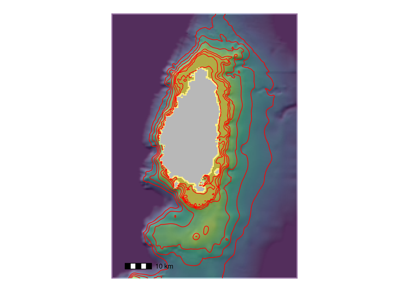
Bathymetry
One can obtain bathymetry data from https://download.gebco.net. In the following example we read a geotiff file obtained (by mouseclicks etc.) from the gebco site:
download.file("https://heima.hafro.is/~einarhj/crfmr/aux/gebco_2022_n15.7874_s11.5906_w-64.8193_e-58.2495.tif",
              destfile = "carb.tif")
z <- rast("carb.tif")

names(z) <- "depth"
# limit the area to that of St. Lucia
bb <- st_bbox(c(xmin = -61.25, xmax = -60.6,
                ymin = 13.4, ymax = 14.3))
z <- crop(z, bb)
# values above sealevel set to NA
i <- values(z) > 0
values(z)[i] <- NA
# all values deeper than 1500 m set to 1500 m
i <- values(z) < -1500
values(z)[i] <- -1500

# hillshade with grey colors
slope <- terrain(z, "slope", unit = "radians")
aspect <- terrain(z, "aspect", unit = "radians")
hill <- shade(slope, aspect, 10, 340)

p <-
  ggplot() +
  theme_void() +
  geom_spatraster(data = hill, show.legend = FALSE) +
  # Note the scale, grey colours
  scale_fill_gradientn(colours = grey(0:100 / 100), na.value = NA) +
  ggnewscale::new_scale_fill() +
  geom_spatraster(data = z, alpha = 0.55, show.legend = FALSE) +
  geom_spatraster_contour(data = z, colour = "red", linewidth = 0.4,
                          breaks = c(-25, -50, -100, -200, -500, -750, -1000)) +
  scale_fill_viridis_c() +
  #geom_sf(data = eez1, colour = "white") +
  theme(legend.position = "none") +
  annotation_scale(pad_x = unit(1, "cm"),
                   pad_y = unit(1, "cm"))
p